Rainy Night in Ripley Hills

Ripley 1

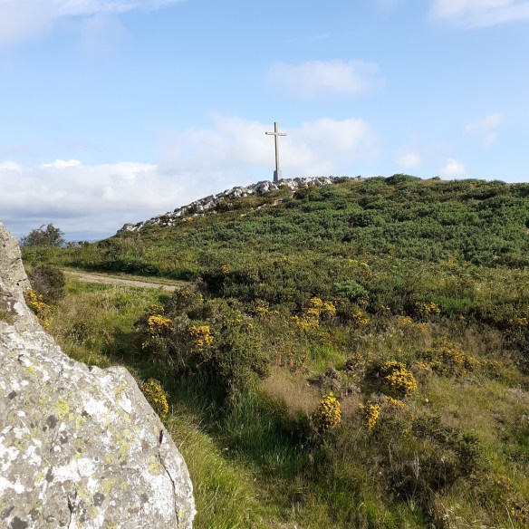
Where Killarney Road reaches its apex, a copse of fir trees guards an ancient stone marker, Saint Saran’s Cross. This mystery-laden oasis atop the hill is surrounded by a modern housing estate called Fairyhill. On the falling eastern slopes is another estate, Ripley Hills, which I call home. It was built in 1983 beside two grand houses of the nineteenth century, which were curiously conjoined: Rahan and St. Helen’s. Rahan House was once the abode of writer Arthur Conan Doyle. During his stay he developed an interest in the supernatural and wrote a book called The Coming of the Fairies.

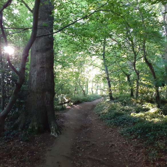
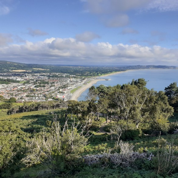
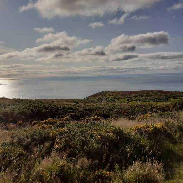
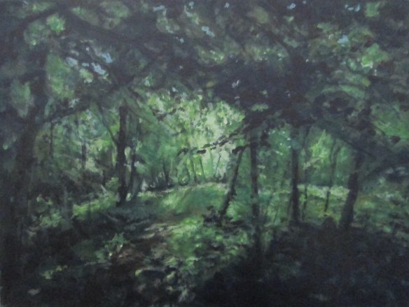
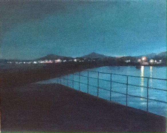
Rahan and St Helen’s were destroyed by fire shortly after I took up residence nearby and I witnessed the sad event from my rear window.  They took their mysteries with them, and their only vestige is a calm green space in Ripley Court. While the urban environment continues to grow, the landscape continues to give. Fabulous views of Bray Head and the Sugarloaf Mountains are always a reward for a walk around Ripley Hills and environs. The estate itself, sylvan and landscaped is a suburban pleasure too. I have been there long enough to witness it beneath blue skies and blankets of snow. But in the dark of night, with rain falling, it is sometimes more magical still.

Something’s gotten hold of my heart

Keeping my soul and my senses apart

Something’s gotten into my life

Cutting its way through my dreams like a knife

Turning me up and turning me down

Making me smile and making me frown

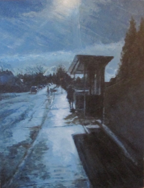
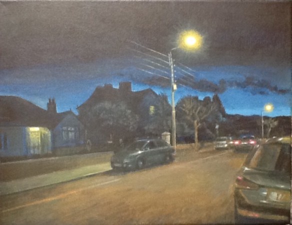
You know the feeling you get when the rain is falling and falling and you stand to look up into it and feel yourself rising up until you reach that point of equilibrium where the rising spirit and the falling water are as one, poised together in endless stasis. A moment like that, held in the sodium glow of the streetlamps, is what this painting is about. Trying to capture it, I reached for a palette richer and more varied than my dark blues and greys. 

Something’s gotten hold of my hand

Dragging my soul to a beautiful land

Something has invaded my mind

Painting my sleep with a colour so bright

Changing the grey and changing the blue

Scarlet for me and scarlet for you

Something’s Gotten Hold of My Heart, was written by Roger Greenaway and Roger Cook and was a hit for Gene Pitney in 1967. Born in 1940, Pitney was a singer songwriter who first achieved fame in the early sixties with movie theme songs. Perhaps his best known hit was the intense narrative Twenty Four Hours from Tulsa, a Bacharach David song in1963. His songwriting credits include Hello Mary Lou which was a hit for Ricky Nelson. In 1989 Pitney scored again with Something’s Gotten Hold of My Heart in a duet version with Mark Almond. He died in 2006.

In a world that was small

I once lived in a time there was peace with no trouble at all

But then you came my way

And a feeling unknown shook my heart, made me want you to stay

All of my nights and all of my days

Climbing Bray Head

B.Woods Aug20

Bray Head is the defining geographical feature of the town. Rising sheer eight hundred feet from the Irish Sea, the headland is capped by a large stone cross, erected for the Holy Year of 1950. The headland is a sizeable upland area. Its ridge consists of five or so mounds of exposed quartzite, like the knuckles of a fist. While the cross marks the headland, the summit is a couple more humps inland. 

The climb to the Cross is a must for visitors, and a regular pastime for locals. The route from the seafront is steep, though the incline can be tempered by zigzags through natural woodland. A longer but more gradual climb runs from the junction of the Southern Cross and Greystones Road, adjacent to Bray Golf Course. 

B.Golf Aug20

The lower entrance, through the gates, makes for a lovely start through dense deciduous woodland. Dappled green and umber, but allowing the occasional patch of sunlight through, this is a cool and mesmeric way to disguise the climb. Merging with the golf course path, the incline hardens, but compensates with fabulous views over the Sugarloaf Mountains, to the Wicklow Mountains beyond, with Bray’s urban landscape leading down to a blue sea, and South County Dublin’s rocky bays and inlets leading the eye on to the distant city. 

B.View Aug20

At the top of the path there’s a short, stiff clamber over rocks just above the treeline before the path resumes. Another option, is to veer right for a longer, smoother ascent, with some wonderful rugged scenery above the manicured golf course. Emerging from the scrubland, there’s a smooth path leading up to. the Cross. The headland offers dizzying views over ocean, coast and townscape, framed by the majesty of the Wicklow Mountains. 

B.Cross Aug20

The hummock is often thronged, but often not. People come and go, and you can linger as long as you like to get the best from the experience. And there’s a surprisingly large expanse of wilderness up here to explore, or just to be away from it all. We take the path towards the stile, but leave it to ensconce ourselves beneath the second knuckle in, and sitting on grass with the rock guarding our backs, relax for a while and bathe our eyes with sunshine and the blue and glinting Irish Sea.

It doesn’t take long before I feel a song coming on.

Somewhere beyond the sea

Somewhere waiting for me

My lover stands on golden sands

And watches the ships that go sailing

La Mer was written by Charles Trenet, a homage to the view of the Etang de Thau, a lagoon he passed on the train between Montpellier and Perpignan in the South of France. Jack Lawrence’s Anglo version gives a romantic twist to the descriptive thrust of the original. It was a major hit for Bobby Darin, which is how I know it. It features on his 1961 compilation, the Bobby Darin Story, the oldest, probably, and most bedraggled album in my collection.

B.Sea Aug20

Somewhere beyond the sea

She’s there watching for me

If I could fly like birds on high

Then straight to her arms I’d go sailing.

In Killruddery Woods

Kilruddery woods

From our last stop, the Bus Stop, Killarney Road makes for the M11 to the southwest. The road to the left is officially known as Oldcourt Park, but known locally as the Soldiers Road.  It runs alongside the ravine carved by the Swan River. Lost amongst the trees, the ancient tower house of Oldcourt Castle looms above, forever beyond reach. The river slithers through Wheatfield, past Swiss Cottage, across the Boghall, up to Southern Cross and on to Killruddery where the brook drains off Giltspur, or the Little Sugarloaf. 

These lands south of Bray were granted to Walter de Riddlesford, one of Strongbow’s loyal adventurers in the invasion of 1169. The large demesne is centred on Killruddery, the Church of the Knight. The Brabazon family came into ownership of the estate in the early 16th century through William Brabazon, Lord Justice of Ireland. The title Earl of Meath was granted to his great-grandson William in 1623. Killruddery House had to be rebuilt following destruction in the Cromwellian wars of the mid century. The current building is largely an 1820s reconstruction in the Tudor revival style. The original gardens remain. Designed by the French gardener Bonet, they are a unique example in Ireland of seventeenth century design, haunted with an exquisite Gothic gloom. Classically inspired additions blossomed in the eighteenth and nineteenth centuries.

The house and gardens are a popular attraction, with coffee shop, farmers market, garden centre and regular music and art events. There’s an adventure playground and Ireland’s largest obstacle course. Best of all are the walks through the estate, beyond the walls where nature wrestles amiably with farmland and forest. I have variously met friends and strangers, no one at all, amiable vikings and post apocalyptic hippies (these later visions being on film set).

I recently took a path less travelled on the borderline between Killruddery and Belmont. In natural woodland on a sunny day there’s a tangible frisson in the air as light and dark dance with uninhibited abandon, together all alone, but for me. This acrylic is unusual for me in the choice of palette, which is very, very green.

But most of all I miss a girl in Tipperary town

and most of all I miss her lips as soft as eiderdown

again I want to see and do the things we’ve done and seen

where the breeze is sweet as shalimar and there’s Forty Shades of Green 

This song became such an iconic evocation of the Emerald Isle that it is presumed to have originated here. In a way it did. Johnny Cash wrote the song when touring Ireland in the late fifties. Once, after performing the song, a fan thanked him for his respect in singing a grand old Irish traditional air.

Bus Stop

Bustop1

Bus stop, wet day, she’s there, I say

Please share my umbrella

Bus stops, bus goes, she stays, love grows

Under my umbrella

All that summer we enjoyed it

Wind and rain and shine

That umbrella we employed it

By August she was mine

From the Swan River, Killarney Road keeps rising until it tops Fairyhill. Small estates line  the road, most dating from the nineteen eighties. The 145 bus route takes an unexpected right turn at Killarney Lane and the stops before the junction are mine. Across the road, the Nurseries lie beyond a triangular green planted with a copse of silver birch and sycamore. On this side, the western, the footpath runs continuously from the town to the M11. The covered bus stop here is a morning refuge for northbound commuters, whether heading for Bray Dart or Dublin. The 145 connects as far as Huston Station via the N11 and Dublin City Quays. I usually hike to the Dart on my northbound excursions, but the bus has its own consolations. More quaint and communal, and the serpentine route gives a scenic tour of south Dublin. There’s an intimacy too in the bus stop mythology. At least, that was the experience of my generation back in the day. The anticipation, the tension, the longing; and that was just for the vehicle. Love might also blossom, in wind and rain or shine. 

That’s the way the whole thing started

Silly but it’s true

Thinking of our sweet romance

Beginning in a queue

In this acrylic, we approach the bus stop after a heavy shower. The sky is clearing and the surface below us glares painfully, but beautifully. At the junction, the Oldcourt is off to our left, and the nearby right turn heads towards the Ardmore Film Studios on Herbert Road. Ahead, the Killarney Road weaves steeply upwards through a portal of oak trees towards Ripley Hills, and the apex at Fairyhill, crowned with its stand of pines.

Every morning I would see her

Waiting at the stop

Sometimes she’d shop

And she would show me what she’d bought

Other people stared

As if we were both quite insane

Someday my name and hers

Are going to be the same

Bus Stop was written by Graham Gouldman who would later form 10cc. He credits his father with starting  the lyrics from Graham’s own idea. Getting started is the thing. “It’s like finding your way onto a road and when you get onto the right route you just follow it.” A bit like Killarney Road, then. Bus Stop was the breakthrough US hit for Mancunian group, The Hollies, in 1966. I heard it on my first long playing album Hollies’ Greatest Hits (Parlophone) which I got for my thirteenth birthday. 

Bray – Overlooking the Swan River

Swan R 2

At the top of Bray Main Street there’s a fork in the road. Imagine this through time as being something of a village green, with timber frame tavern and monthly fair days. The Old Town Hall from 1881 originally included a covered market and is Elizabethan in style. Picture it in a Tudor setting, or perhaps Dickensian, surrounded by leaning buildings with gabled fronts and muntin windows.

The fork to the left is the coastal route, climbing up to the gap between Bray Head and Giltspur, (the Little Sugarloaf), and on to Greystones. To the right, Killarney Road is the principal route south towards Wicklow Town and Wexford, via the N11. Gothic redbrick houses of the Fin de Siecle line the road out of town, set in extensive gardens behind granite walls.

The road rises towards the massive spire of Christchurch, Bray’s towering landmark. The Gothic revival church, built of stern granite blocks, was completed in 1863 to serve the Church of Ireland community. The tower was added some decades later, the octagonal spire rising to 175 feet is garlanded by stone pinnacles. Christchurch’s imposing presence is further emphasised by its elevation, standing atop the Rock of Bray, the summit of the rising ground that defines the town.

Past Church Road, we crest the hill, and from here the route falls into the valley of the Swan River. This tributary of the Dargle rises in Kilruddery Estate on the slopes of Giltspur, flowing through Oldcourt and past its castle, under the bridge below our vantage point and on to the Dargle. The Swan trails a score of varied woodland along its deepening chasm. A rich mixture of oak, ash, birch, pine and poplar, with some exotics such as Eucalyptus, cloak the area with a sylvan beauty. With the town centre only a couple hundred metres behind us, and the suburban housing estates gathered on the next hill, this spot is like a blink in time, remote from surrounding urbanisation.

This view, rendered in acrylic, is taken from the junction with Beechhurst estate. Christchurch is out of sight to our left, Patchwork Cottage, to the right, and the bridge await below. After a long uphill climb from the seafront or Dart station, it’s a welcome downhill stretch. Past the bridge, the road will rise continually to Fairyhill, surmounted by the ancient, weathered cross of St Sarain, the area’s patron saint. (Killarney is an Anglicisation of the Gaelic ‘Church of Sarain’.)

On this day, a shower has just cleared, veils of cloud are pulling off to the West. Ahead the sun has broken through, turning all it touches to silver.

Bray Seafront – Looking North

IMG_5206

Up until the mid nineteenth century, Bray seafront was a stony beach stretching between Bray Head and a craggy outcrop a mile to the north on which sat a Martello Tower. The crag overlooked a small dock and the Dargle River opening into the sea. In the 1850s the Dublin to Wexford railway line passed along the shoreline and this ultra modern mode of transport enabled many more people to live here by the seaside. Strand Road was developed with fine Victorian houses, the sea was pushed back and the Esplanade established as a long linear parkland. The Promenade, atop the sea wall, completed the picture in the 1890s. Not all that much has changed over the intervening century.

IMG_5185

The seafront is Bray’s principal attraction for visitor and resident. Throughout the year, but especially in summer, people come for all the fun of seaside entertainment. They throng to the summer carnival, the various outdoor gigs and events, the amusements, the bars, cafes, icecream parlours and restaurants. Or they take a walk along the Promenade or up Bray Head, or just sit on the beach or the Esplanade. This is what people do, crowds of them, together and all alone.

IMG_5187

Our present phase of isolation has robbed us of this fun, but our time will come round again. This is what people do. I’m fortunate in that I’m a Bray resident, and live within the distance parameters of the seafront, and indeed the Cross at the top of Bray Head. I’ve been familiar with this joint since coming here for holidays in 1963. As Gerry and the Pacemakers said at the time: I Like It!

I like it, I like it,

I like the way you run your fingers through my hair

And I love the way you tickle my chin

And I like the way you let me come in

when your Momma’s not there.


IMG_5192

The particular stretch of the seafront which I’ve painted has proven a happy hunting ground for me too. The block of buildings to the left featured in one of my first short stories, called Coda. It won the Bray People short story competition and was the opener for my first collection Blues Before Dawn. It’s a macabre story featuring a couple of musicians, one an Italian running a seafront chipper, the other, the narrator, a bit of a psychopath. In the eighties, the Fun Palace stood where the Silver Strand is, and I borrowed that name for the regular spot where our heroes played. There was also a small Italian chipper, extreme left, which featured too. As for the Fun Palace, the old facade, like the Silver Strand but with timber cladding, was immortalised in an illustration I did. It featured in my first art exhibition in the Bank of Ireland on Main Street. It was the only artwork that sold. I wonder where it resides now.

IMG_5195

Further on, perspective lines converge on what we call The Dug Inn. Mick Duggan’s pub has been through a few name changes since, most notably Katie Gallagher’s. Still in the family, who run a couple more Bray licensed premises, it now has three names: The Box Burger, Platform Pizza and the Ocean. Just beyond, the Hibernia was once a gig hotspot known as The Mississippi Rooms. It still runs folk music gigs midweek.

IMG_5202

Looking to the right hand side, you’ll see the shape of Killiney Head beyond the lights of the Promenade. Nearby, to the right, the modern complex that holds the Bray Sealife Centre. Established in the eighties, it was originally a rather lumpy granite clad modernist structure. It was later recast as a sleek postmodern pavilion. The gastrobar visible here, was originally known as the Barricuda, and now houses Butler and Barry’s. The upstairs area features a glass wall along the eastern side giving fabulous sea views.

Behind me is the central Esplanade and there are many more fine bars facing onto that. Where to go, where to go? I’m gumming for a pint. Only 91 days, 21 hours and eighteen minutes remaining as of Sunday at two o’clock.

IMG_5205

Bray Harbour Blues

IMG_0070 

The guide book description of Bray as “a small fishing village before the coming of the railway,” is a bit misleading. There was fishing in Bray for sure, both inland and offshore, but there was no harbour until the end of the century. What sea traffic there was used a small dock south of the mouth of the Dargle river, occupying what is now the roadway between Martello Terrace and the Harbour Bar. This traditional pub was established in 1831 and is a lively spot, full of music and good cheer. Meanwhile, the harbour itself is home to a large flock of swans and is used mostly by small pleasure craft.

In this acrylic, we stand on the south wall of the harbour, with the lights of the seafront beckoning off to the left. There was once a lighthouse at the end of this pier, but that was swept into the sea in a storm long ago. Now, we are set in darkness, but for the glow of the sunset over the Wicklow Mountains, reflected in the swollen high tide at our feet. Before us is a scattering of harbour lights around the jetty but the Harbour Bar is obscured from us by the dark hulk of intervening buildings centre frame.

But I know it’s there, waiting while I linger a moment, whistling the Bray Harbour Blues.

Bray’s Florence Road

Florence Rd

Alighting from the DART, the main route home, whether by bus, taxi or shank’s mare, leads up Florence Road. Past the delights of Albert Walk and Henry and Rose fish n chipper, the road is straight, mostly residential and lined with pollarded sycamores. There’s a manicured bowling green to the South and a grand Victorian terrace, Florence Terrace along the entire block to the North. Otherwise, the housing mostly consists of detached bungalows with an Arts and Crafts feel and distinctive orange tiled roofs. These date to the 1920s and also feature in other streets around the town centre. 

As with much of Bray there is a whiff of merry olde England, but not quite. It’s as if you turned your back for an instant and all the trees and undergrowth took a surreptitious step forward, encroaching on the serenity just that little bit too much. This alternative spooky ambience is emphasised by  a few fin de siecle detached Gothic houses. At the crossing with Wyndham Park, Florence House and Arno House from the late 1880s form an imposing gateway to the shaded sylvan area beyond. Further on is Bray Library, a granite Carnegie library from the early twentieth century. 

Crossing Eglinton Road, the rational straight lines of Dargan’s planning bend somewhat towards the lines of the original old manor town. The methodist church is to the left and beyond that the street dons its working clobber as it heads up to meet Main Street at the t-junction. The Church of the Most Holy Redeemer closes the vista spectacularly. In fact, Florence Road didn’t push through to the Main Street until 1903; a date commemorated on the gable of Bannon’s Jewellers.

This view, in acrylics, is from the eastern stretch of road approaching Wyndham Park, looking southwest. Florence Terrace is behind us. Ahead we see the silhouette of Arno House, built in 1889. It is late winter after work, tea time. The sun has just set in the West and the lights are fading on. 

Bray Seafront Evening

Bray Sfront art

At the start of the 19th century, the recreational and romantic potential of the sea was just being discovered. Up till then, such benefits it gave were seen as limited to its harvest of food and its use as a transport route. Mostly it was regarded as an unpredictable menace; a source of storms, piracy and invasion. This is illustrated by the fate of Bray’s two Martello Towers, constructed in 1804 during the Napoleonic Wars. One, positioned at sea level  midway along the seafront, having fulfilled its original purpose was destroyed by storm some eighty years later. The other, atop a mound at the north end of the seafront, repelled Bonaparte but was occupied in the 1990s by another diminutive general, Bono. It survived. 

Meanwhile, the Romantic era recognised other qualities of life by the seaside. Besides health and wellbeing, the spiritual and aesthetic drama of seascape and shore would increasingly inhabit the human perspective.

Bray, remote and battered gatepost at the southern end of the Pale, attracted romantic and prosperous souls to its dramatic combination of mountain and coast. By the mid 19th century, the expanding town was being connected to the city of Dublin to the north by rail. The town’s population grew as did the seasonal tide of visitors. William Dargan, the railway entrepreneur, undertook the ambitious conversion of Bray into the ‘Brighton of Ireland’. Amongst his plans was the development of the seafront. The Esplanade, almost a mile in length, was laid out with a Promenade to the base of Bray Head. Constant flooding resulted in the construction of the sea wall, with the Promenade on top, in the 1890s. The Harbour was completed at the end of the century, separated from the Esplanade by Martello Terrace.

1 Martello Terrace features in James Joyce’s Portrait of the Artist. Joyce lived here as a child. Longtime resident, former Government Minister Liz McManus, reckons it may also have inspired the phrase found in Ulysses: the snot-green, scrotum tightening sea.

In this view we look south along the length of the Esplanade. The Harbour and Martello Terrace are behind us. A foursome heads out on, or continues, a night out. Just ahead, to the right, is the Silver Strand Amusements, formerly the Fun Palace, setting for my first Bray short story: Coda. To the left is the Sealife Centre, with the lights of Butler and Barry’s Bar and Grill. Further on, the bright lights glow and beckon revellers to the nightspots: The Martello, the Porterhouse and Jim Doyle’s. This is where stories begin, of sex and drink and rock n roll.

Bray Main Street

Bray Main Street

Bray, as a definite built location was established by the Normans under Richard de Clare (Strongbow) in 1169 on lands granted to Walter De Riddlesford. It guarded the fording point of the River Dargle where the town bridge now stands. The location marked the southern extent of the Pale, the area of Norman influence around Dublin. As such, Bray was a frontier fortress, sporadically attacked by native clans from the south: the Byrnes and O”Tooles. The castle was built on the high south bank of the river, but little remains beyond its vague footprint. Stone steps cut into the rock descending to the river are still visible. St Paul’s Church was established to the front of the fortification, the current building dating to 1609 is Bray’s oldest. The manorial village grew along Main Street heading south towards the Kilruddery estate of De Riddleford, now owned by the Earl of Meath, head of the Brabazon family.

This view of Bray looks south along the rising Main Street. The Town Hall at the far end is hidden by the bend in the road. The bridge is directly behind us with St Paul’s and the castle behind us to the right. The Royal Hotel, originally Quin’s, one of Ireland’s oldest rural inns and the courthouse of 1841 are just behind us to the left. Ahead, to the left at the traffic lights, Quinsboro Road leads down to the seafront. The white Art Deco building to the right was once the local office of Dublin Gas but is now vacant. On the left a few doors up, the fluorescent lights signal The Florentine, a pub once known as the Olde Bray Inn. And this is indeed the old centre of Bray, dating back to days long before the coming of the railway in the 1850s.

On this spot, almost eight hundred and fifty years ago, you would be leaving the relative security of Bray’s fortifications behind and heading into the untamed lands of the O”Byrnes of Cuala. You would now be “Beyond the Pale”. On a late Autumn night in 2018, I am heading home to my castle, just over a mile due south, near the brow of a hill where an ancient Celtic cross is planted. Sometimes you can blink and the accretions of history fade. Blink again and the security of neon and petrol return, familiar enough to embrace in the dark.